How big is the African Savannah?
There’s a figure I show in my seminars that half the audience doesn’t believe. It’s a map of Africa and on it I have superimposed an outline of the lower 48 states of the United States and Europe. They cover half of Africa’s extent. The way I arrange them, they cover Africa’s savannahs. “So is Africa that big?” “Yes,” I reply. Savannahs are areas that get enough rain not to be desert but not too much to be closed-canopy forests. They run from South Africa — where I put California in my figure) to Kenya (and where I put Maine) and westward to the Atlantic Ocean of Senegal (across which I stretch Europe.)
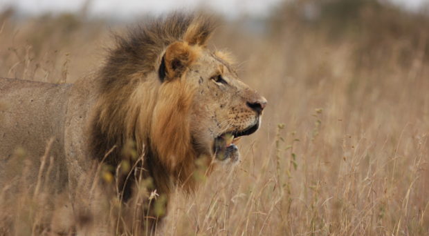
Somehow, we all have a vision of these areas, likely based on wonderful National Geographic specials. Large herds of elephants stride across open grassland, a pride of lions is hunting a zebra; giraffe are using their long blue tongues to shred leaves from a very thorny acacia tree. Some parts of Africa are indeed just like that! But much more is open woodland, a mix of grasslands, wetlands, and scattered dry forest. And even very much more is not wild at all but a landscape on which live millions of people, their numbers doubling every thirty years or so. So how much of wild life remains in Africa?
Ask a comparable question about the steamy tropical forests of the Amazon and the answer is easy. Look at Google Earth and one readily sees what’s forest and what has been cleared for human use. For savannahs with their sparse vegetation, the difference between natural patchy forests and grasslands and the areas from which people have cleared their fields is much less obvious. From far enough above the Earth’s surface, they look the same.
There are people who classify land use, of course. When we turned to their maps, there was a wide strip of savannahs running west-east, south of the Sahara, then turning south towards South Africa that showed as being a natural landscape. Wetter areas were where the maps showed human use. These maps were terribly wrong.
Mapping the African Savannah
First, we’d been on the ground in some of these areas and knew that there were many scattered farms. Second, we could look much more closely at the Google Earth images and see the areas converted to human use. Those who did the classifications were looking at relatively coarse satellite imagery. So, how should we map out where people are?
It’s the tried-and-true method of many graduate students, beer (for those old enough) and pizza. Each student, so bribed, would spend a couple of hours each session, digitising where crops and settlements were. After many thousands of hours of work, we produced a very detailed map of where people now live.
It’s a map of desperation. I flew from the Horn of Africa to Johannesburg a few days ago. Across many dry areas, people eke out a living on barely fertile soils. It’s also a map of conflict, as rapidly increasing human populations — Muslims from the north and Christians from the south, move into these areas and compete for the land.
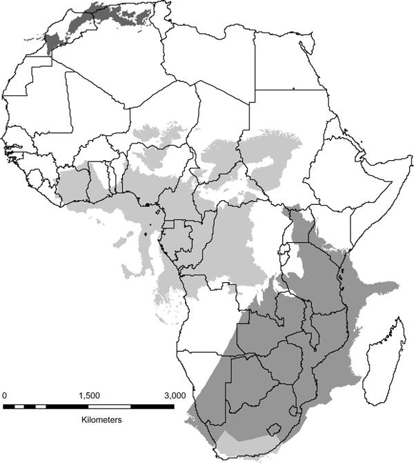
For us, it was a map of where lions could not live. We wanted to know how much of savannah Africa could support lions and, by extension, all those familiar savannah species. The overall answer is that only about a quarter of the once extensive savannahs are sparsely populated enough to have a chance at having wildlife.
This is a striking statistic. About half of the world’s remaining tropical moist forests — “rainforests” — remain. Savannah ecosystems are in much worse shape. West Africa, in particular, has very few wild areas. Indeed, we found that there even national parks had substantial numbers of people living in them.
The point of all this effort was without a good map, we could make not sense of the scattered, often old, and very often poorly documented data on how many lions remain in Africa. With a good map, we could assess the numbers, check their credibility, and draw an overall conclusion: there are likely just over 30,000 lions remaining in Africa. (That’s down from hundreds of thousands in the past.) Many of those are populations that are small and isolated surrounded by large numbers of people. Very few lions indeed remain in West Africa. Only about 24,000 lions live in “strongholds” — places that support large enough numbers to be viable.
Why does this matter?
This project was part of National Geographic’s Big Cats Initiative. It works to find creative ways of preventing lions killing people’s livestock and so people killing lions in retaliation. We now have a map of where to place our conservation efforts, and an assessment of how many lions we have to see if we make a difference.
Read full journal article: The size of savannah Africa: a lion’s (Panthera leo) view

Stuart Pimm
Latest posts by Stuart Pimm (see all)
- African Savannah: a smaller home for lions? - 11th July 2016